Camino Francés stages: from Saint-Jean-Pied-de-Port to Santiago
The Camino Francés runs about 770 to 800 km from Saint-Jean-Pied-de-Port to Santiago de Compostela. We break it into its regional stages, explain the winter closure over the Pyrenees and the Compostela rules, then look at two long-distance trails for walkers who want something wilder.
, 7 min read
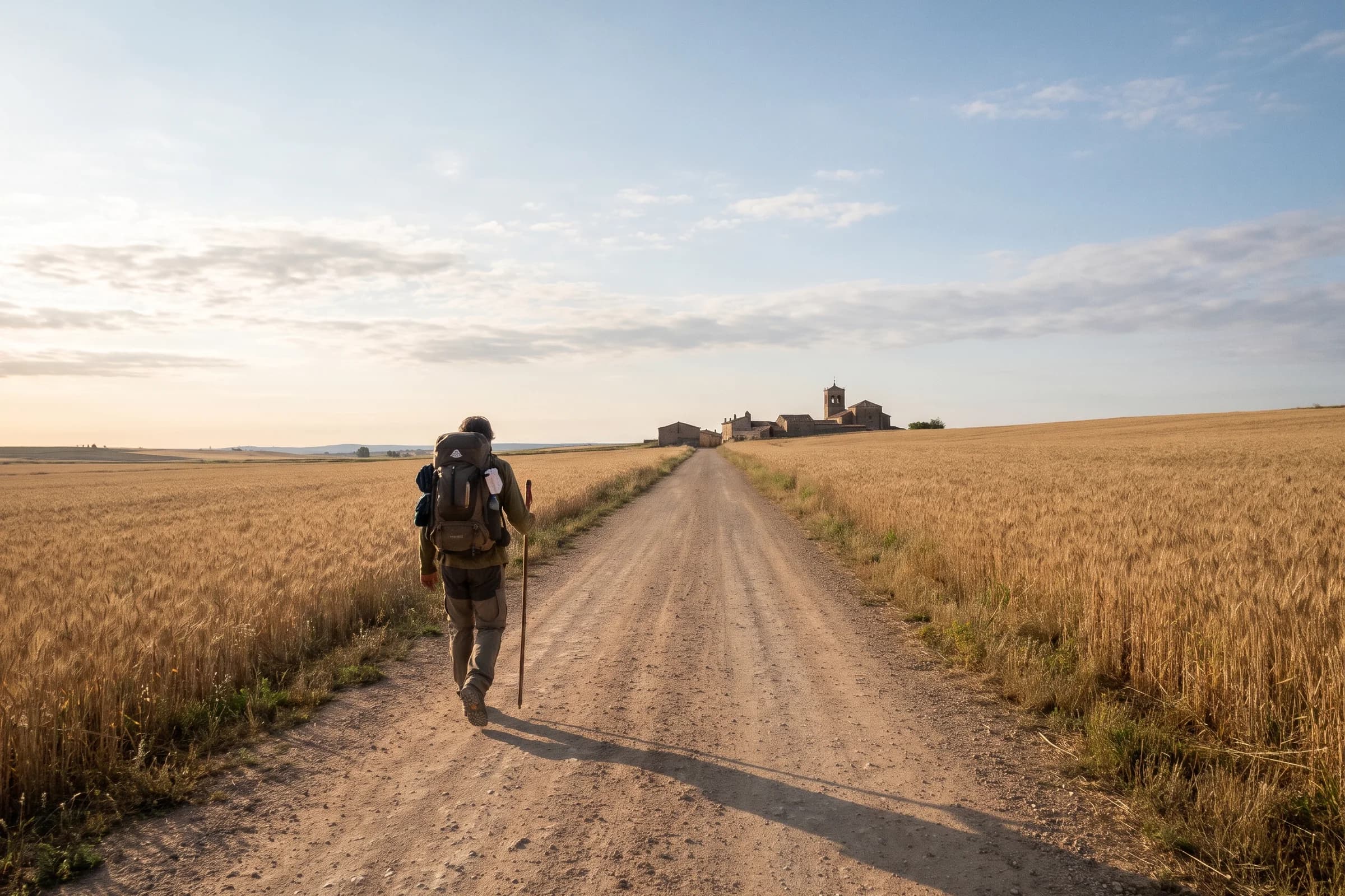
The Camino Francés, the French Way of the Camino de Santiago, runs from Saint-Jean-Pied-de-Port at the foot of the Pyrenees across northern Spain to Santiago de Compostela. Depending on the source and the variants you take, it is roughly 770 to 800 km, about 480 to 500 miles. Spain’s national tourist board recommends 31 to 33 daily stages across its four Spanish regions, plus the day over the Pyrenees, which works out at around five weeks of walking. It is, in the tourist board’s words, the most popular of the Camino routes.
Below are the Camino Francés stages grouped by region, with the distances and number of stages the tourist board suggests for each, then the rules for the Compostela certificate. At the end are two long-distance trails for readers who want the opposite of a pilgrimage.
Camino Francés at a glance
Start: Saint-Jean-Pied-de-Port in France. In Spain the route can also begin at Roncesvalles in Navarre or at Somport in Aragon.
Finish: Santiago de Compostela.
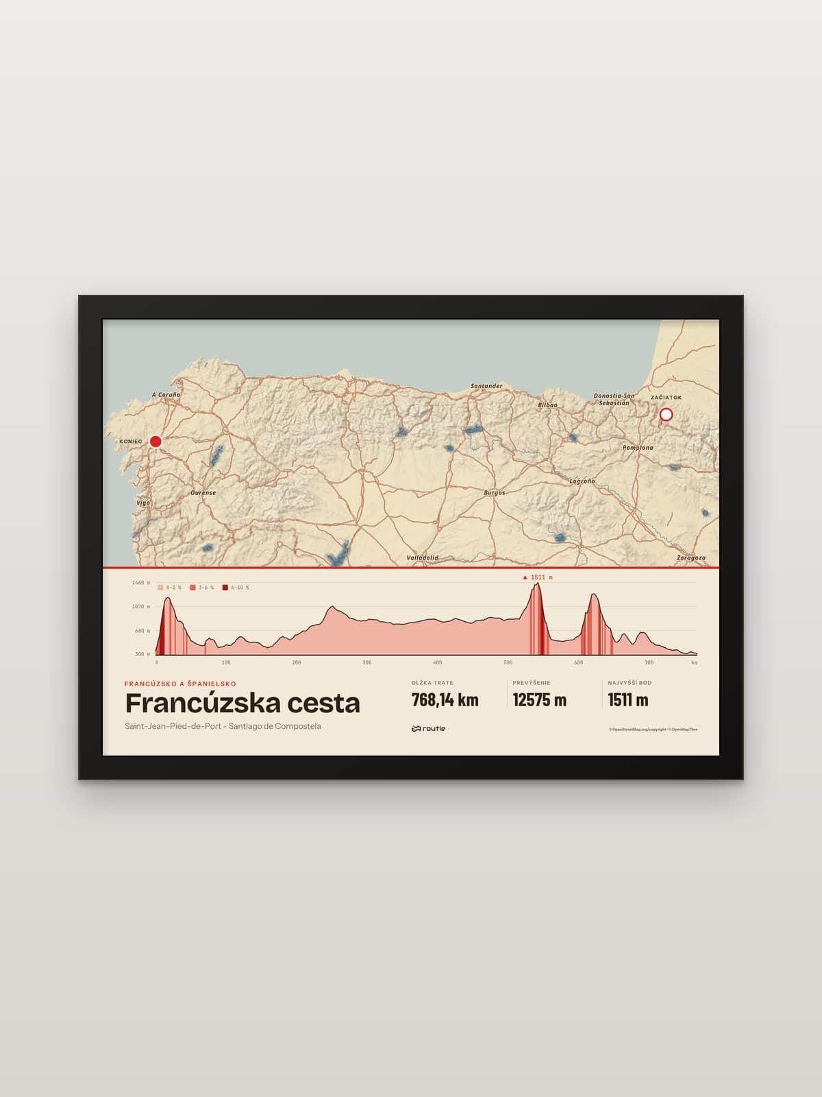
Distance: roughly 770 to 800 km. The line on our print measures 768.14 km (about 477 miles) with 12,575 m of ascent.
Regions: Navarre (150 km), La Rioja (90 km), Castile and León (380 km) and Galicia (160 km).
Stages: 6 to 7 in Navarre, 4 in La Rioja, 14 in Castile and León and 7 to 8 in Galicia, plus the Pyrenees crossing.
High point: the crossing between Astorga and Ponferrada, where the Cruz de Ferro stands at about 1,500 m. Our line peaks at 1,511 m on this stretch.
Best time: spring, and September to October, according to the tourist board.
Camino Francés stages by region
Stage one: over the Pyrenees to Roncesvalles
The first day is one of the hardest. The eastern variant climbs more than 1,200 m from Saint-Jean-Pied-de-Port to the Lepoeder pass at 1,432 m. Every year from 1 November to 31 March the Government of Navarre closes it, and pilgrims must take the western variant through Luzaide/Valcarlos and the Ibañeta pass to Roncesvalles. The closure has been in place since 2015 to protect pilgrims and the rescue services, who were often called out there in winter; the details are in the Government of Navarre’s notice.
Navarre: 150 km, 6 to 7 stages
From Roncesvalles the route crosses Pamplona and continues to Puente la Reina, where the Aragonese branch from Somport joins it. From here on there is one Camino Francés all the way to Santiago.
La Rioja: 90 km, 4 stages
The shortest region, passing through Logroño. Navarre and La Rioja together make 10 to 11 stages, roughly the first third of your time on the route.
Castile and León: 380 km, 14 stages
The longest section by far. The tourist board lists the main stops as Belorado, Atapuerca, Burgos, Hornillos del Camino, Castrojeriz, Boadilla del Camino, Frómista, Carrión de los Condes and Sahagún before León, then on to Astorga, Ponferrada and Villafranca del Bierzo. Burgos and León are the largest cities on the route, and the tourist board suggests a day in each. Between Astorga and Ponferrada you cross the high ground of the Cruz de Ferro, which stands at about 1,500 m; the highest point of our line, 1,511 m, is on this stretch.
Galicia: 160 km, 7 to 8 stages
You enter Galicia at O Cebreiro, on a path the tourist board describes as quite difficult but extremely beautiful. From there it is 160 km and 7 to 8 stages to Santiago de Compostela.
How to get the Compostela
The Compostela is issued by the Pilgrim’s Reception Office in Santiago. According to its Compostela requirements, you need to:
walk or ride on horseback at least the last 100 km continuously on the same route, or cycle at least 200 km,
carry a pilgrim credential (Credencial del Peregrino) stamped along the way, with a stamp and date at the start and end of each stage on the minimum-distance section,
walk your stages in chronological and geographical order, with the final stage reaching the cathedral.
The Compostela is awarded to those who make the journey for religious or spiritual reasons. The office is at Rúa Carretas 33 and opens daily from 9:00 to 19:00, except 25 December and 1 January.
Other Camino routes
If five weeks is too long, the tourist board describes several shorter Caminos. The Spanish section of the Portuguese Way from Tui is about 119 km and among the flattest routes, the English Way is about 73 km from A Coruña or 112.5 km from Ferrol, and the Primitive Way, which follows sections of the original route, is around 300 km. The Northern Way along the coast is about 800 km, a similar commitment to the Camino Francés.
Corsica: the opposite of a pilgrimage
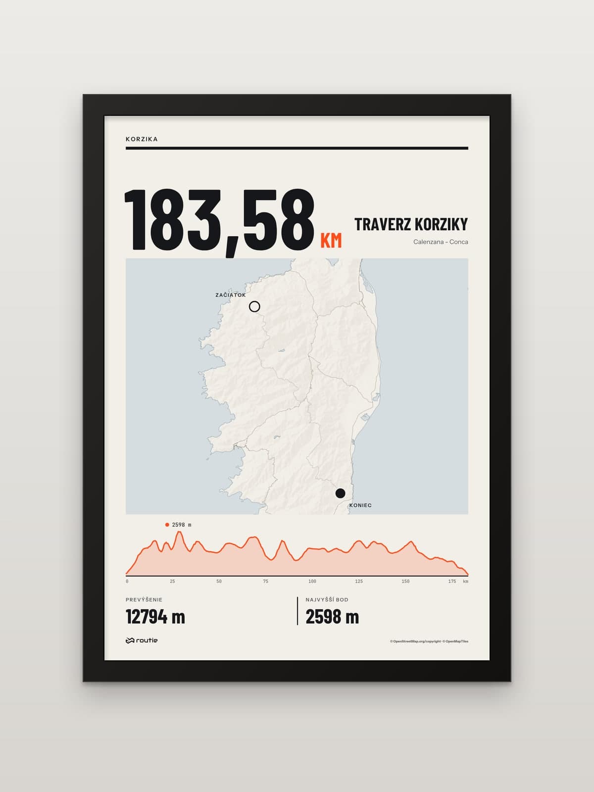
If the Camino appeals for its length but you miss the mountains, Corsica is the counterpoint. The GR20 crosses the island’s mountains from Calenzana in the north-west to Conca in the south-east. The French hiking federation describes it as often considered the hardest long-distance path in France, even in Europe; its guidebook plans 16 days of walking, with stages climbing more than 600 m. The huts along the way are run by the Corsica Regional Natural Park. For 2026 they opened from 16 May to 4 October, and booking was compulsory for every option, bivouac included, online only. Our Corsica traverse print follows the line from Calenzana to Conca: 183.58 km with 12,794 m of ascent.
The SNP trail: Slovakia’s long-distance route
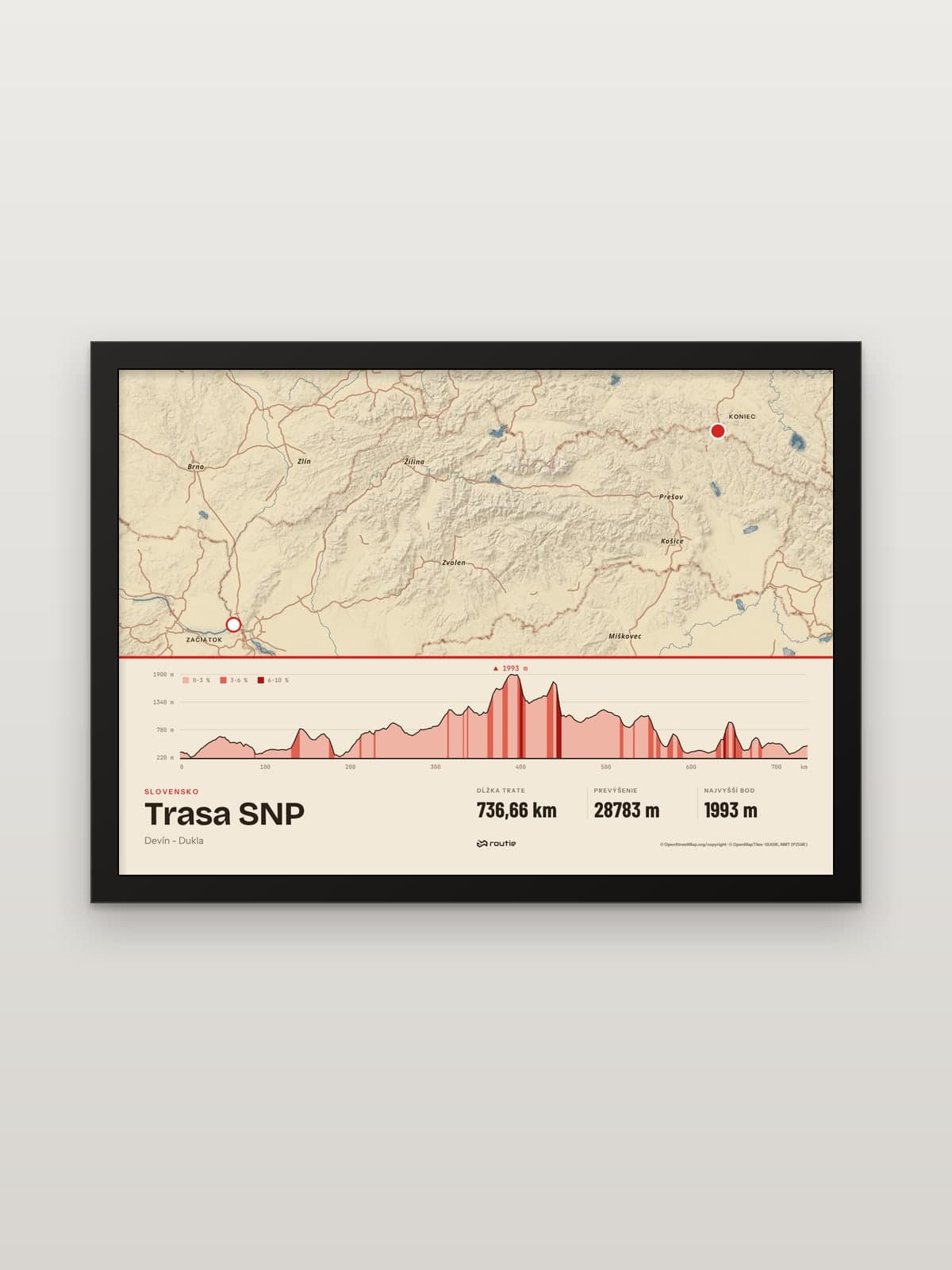
For a quieter European long-distance trail, Slovakia has its own: the SNP trail runs across the country from Devín in the west to Dukla in the north-east. The line on our print measures 736.66 km. Its highlight is the main ridge of the Low Tatras, which we cover in our Low Tatras ridge hike guide.
The routes as prints
The French Way print is in landscape format and shows the whole route from Saint-Jean-Pied-de-Port to Santiago. We 3D-print the route in matte PLA and glue it onto the glass exactly above the route on the map. Its height follows the terrain, 4 mm at the lowest point and 15 mm at the highest by default, so the Pyrenees, the Cruz de Ferro and O Cebreiro stand up from the print.
Each print comes in A5, A4 or A3 with a black or white frame, and every print is made to order. If you walked a different Camino, or only the last 100 km, upload the recording from your watch as a GPX, TCX or KML file and design a print of your own route.
If mountains are calling after Santiago, our guide to the Mont Blanc loop trek covers the classic hut-to-hut loop through France, Italy and Switzerland.
Frequently asked questions
How long is the Camino Francés in km and miles?
Roughly 770 to 800 km from Saint-Jean-Pied-de-Port to Santiago, about 480 to 500 miles, depending on the source and the variants. The line on our print measures 768.14 km, about 477 miles.
How many days does the Camino Francés take?
Around five weeks of walking. The tourist board’s recommended stages add up to 31 to 33 days from Roncesvalles, plus the Pyrenees crossing from Saint-Jean-Pied-de-Port and any rest days.
How many stages does the Camino Francés have?
There is no single official stage list. Spain’s tourist board recommends 6 to 7 stages in Navarre, 4 in La Rioja, 14 in Castile and León and 7 to 8 in Galicia, which is 31 to 33 stages, plus the opening stage over the Pyrenees.
How hard is the GR20?
Much harder than the Camino. The French hiking federation describes it as often considered the most difficult long-distance path in France, even in Europe, with stages climbing more than 600 m and 16 days of walking in its guidebook. Hut or bivouac bookings are compulsory.